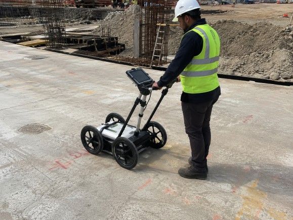
A GPR Survey — short for Ground Penetrating Radar Survey — is one of the most reliable non-destructive testing methods available today for investigating what lies beneath the surface. Whether you are planning excavation, laying new pipelines, or building infrastructure on a sensitive site, understanding what is underground before you dig is not optional — it is critical.
At Bhoojal Survey, we provide professional GPR survey services across India, helping contractors, engineers, infrastructure developers, and industrial project owners make accurate, data-backed decisions before breaking ground.
What is a GPR Survey?
A GPR Survey is a geophysical investigation technique that uses electromagnetic waves to detect and image underground structures, buried utilities, pipelines, cables, and subsurface anomalies — without any excavation.
A GPR system transmits short radar pulses into the ground through a specialized antenna. When these pulses encounter a change in material — such as a buried pipe, cable, concrete reinforcement, or void — part of the energy reflects back to the surface receiver. The system records these reflections and converts them into visual cross-sectional images of the subsurface.
This underground imaging technology is fully non-destructive, meaning no trenching, no drilling, and zero disruption to the site during investigation. It delivers real-time data with high accuracy, making it one of the most trusted geophysical survey solutions in modern engineering.
Why GPR Survey is Important
Underground utility detection is one of the biggest challenges on any construction or infrastructure project. Accidentally striking a buried cable, gas line, or water main during excavation can result in costly damage, project delays, serious injury, or even loss of life.
A professional GPR survey solves this problem before it starts. Here is why it matters:
- Prevents accidental damage to underground cables, pipes, and utility lines before excavation begins.
- Reduces project risk by revealing hidden subsurface conditions that could affect structural integrity.
- Supports accurate infrastructure planning by providing precise location data for buried assets.
- Improves construction safety on busy urban sites, industrial facilities, and government projects.
- Enables faster and smarter excavation planning, cutting time and cost significantly.
- Provides long-term infrastructure protection by mapping existing underground assets for future reference.
For EPC contractors, solar plant developers, telecom companies, and government infrastructure teams working across India, GPR survey services are increasingly a mandatory step in pre-construction site investigation.
Applications of GPR Survey
GPR surveys are used across a wide range of industries and project types throughout India:
- Underground utility mapping for roads, highways, and city infrastructure projects.
- Construction projects where existing underground assets must be identified before foundation work begins.
- Highway and road projects requiring pre-widening utility surveys.
- Airport and railway infrastructure where subsurface investigation is essential before laying new track or runway surfaces.
- Commercial buildings and industrial facilities where hidden structural conditions must be assessed.
- Smart city and urban development projects requiring full utility mapping before civil work.
- Telecom tower and substation projects where underground cable locating is critical.
- Mining and geotechnical projects needing detailed subsurface investigation before drilling or blasting.
- Residential developments in congested urban areas where buried pipeline detection prevents costly incidents.
- Concrete slab scanning for detecting rebar, post-tension cables, voids, and conduits inside slabs before coring or cutting.
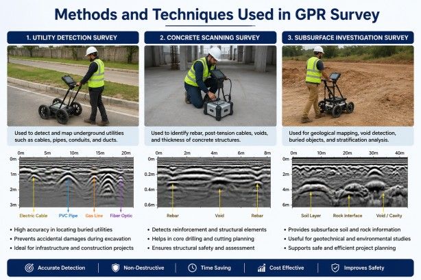
Methods and Techniques Used in GPR Survey
Utility Detection Survey
Utility detection survey is the most commonly requested GPR application. Using radar scanning technology, our field team locates the precise depth and position of underground pipes, cables, conduits, and ducts buried across the survey area.
This method is highly effective for underground cable locating, buried pipeline detection, and mapping utility corridors in congested industrial and urban environments. Our team uses multiple antenna frequencies depending on the required depth penetration, ensuring accurate results even in challenging ground conditions.
Concrete Scanning Survey
Concrete scanning services involve scanning slabs, walls, and structural elements to detect embedded reinforcement bars, post-tension cables, electrical conduits, voids, and other embedded features. This is critical before any core drilling, cutting, or anchor installation to prevent structural damage and protect workers on site.
Subsurface Investigation Survey
Subsurface investigation survey using GPR gives engineers a detailed picture of underground structure detection — identifying changes in soil layering, buried objects, voids, and disturbed ground zones. This data supports foundation design, geotechnical analysis, and pre-excavation safety planning across all types of infrastructure projects.
Equipment and Instruments Used
Our field teams are equipped with advanced ground penetrating radar instruments, high-frequency GPR antennas, GPS mapping tools, and professional data logging systems specifically selected for Indian site conditions.
For hydrogeological survey and borewell location services, we use the SSRMPATS Instrument, GER DETECT, and PQWT at site for open well and borewell location — providing reliable, scientifically supported results for groundwater investigation.
Our full field capability includes underground utility locating instruments, geophysical survey instruments, and dedicated surface scanning equipment — covering advanced geophysical and underground utility survey solutions along with scientific site investigation and subsurface analysis.
Factors Affecting GPR Survey Accuracy
Every GPR survey is unique. Several factors influence signal penetration depth and detection accuracy:
- Soil conditions and moisture content significantly affect radar signal attenuation.
- High clay content or saturated soils reduce effective penetration depth.
- Ground composition including gravel, rock, sand, or fill material changes signal behaviour.
- Underground interference from metallic objects, reinforcement mesh, or overlapping utility lines can complicate interpretation.
- Signal penetration depth varies with antenna frequency — lower frequencies penetrate deeper but with reduced resolution.
- Surface conditions such as pavement type, surface roughness, or obstructions impact data quality.
- Environmental factors including temperature and ground water level changes can affect readings.
- Equipment quality and calibration directly impact the reliability and clarity of subsurface imaging.
Our experienced field team accounts for all these variables during survey planning and data interpretation to ensure the most accurate results possible.
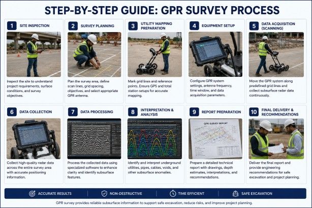
Step-by-Step GPR Survey Process
Here is how we conduct a professional GPR survey from start to finish:
- Site Inspection: Our team visits the site to assess ground conditions, surface access, and survey area dimensions.
- Survey Planning: We define the scan grid, antenna frequency selection, and transect layout based on the project requirements.
- Utility Mapping Preparation: Existing utility drawings and as-built records are reviewed and referenced where available.
- Equipment Setup: GPR antennas, GPS receivers, and data recording systems are calibrated and set up on site.
- Radar Scanning Process: The GPR system is systematically traversed across the survey grid, capturing continuous subsurface reflection data.
- Data Collection: Radar data is recorded in real time with GPS tagging for precise spatial referencing.
- Signal Interpretation: Our technical team analyses the radar reflection profiles to identify subsurface anomalies, utility lines, and underground features.
- Underground Utility Identification: Detected targets are classified by type, depth, and position on the site plan.
- Technical Report Preparation: A detailed engineering report with annotated utility maps, depth measurements, and findings is prepared.
- Engineering Recommendations: Our team provides professional recommendations for safe excavation, further investigation, or project planning.
Benefits of Professional GPR Survey Services
Choosing a professional GPR survey company delivers clear advantages over guesswork or outdated utility records:
- Accurate underground utility detection protects your team and your project from costly surprises.
- Reduced excavation risk lowers the chance of hitting buried cables, pipes, or gas lines.
- Improved construction safety on every project, from industrial facilities to government infrastructure.
- Faster project execution because the team knows exactly where — and where not — to dig.
- Significant cost savings by avoiding utility strike incidents, delays, and emergency repairs.
- Better infrastructure planning with precise subsurface data integrated into design decisions.
- Fully non-destructive investigation with no damage to the site during the survey process.
- Reliable long-term project support through accurate as-built utility records for future reference.
How Can Bhoojal Survey Help You?
Bhoojal Survey is a professional survey consultancy company with extensive field experience across India, supporting electrical contractors, EPC contractors, solar plant companies, telecom infrastructure teams, mining projects, and government infrastructure developers.
Here is what we bring to your project:
- Experienced technical survey team with hands-on GPR and geophysical field expertise across diverse Indian site conditions.
- Advanced GPR survey instruments calibrated for accurate underground utility detection, concrete scanning, and subsurface investigation.
- Professional data analysis with technically sound interpretation of radar profiles and subsurface imaging data.
- Fast reporting services so your project team receives detailed, actionable results without delay.
- Pan-India survey support covering industrial sites, solar plants, substations, airports, highways, mining locations, and urban infrastructure projects from any state.
- Customized infrastructure survey solutions designed around your specific project scope, timeline, and technical requirements.
- Industrial and construction project expertise built through years of on-site survey operations across varied ground conditions.
- Scientific survey methodology ensuring every result meets professional engineering standards.
Whether you need underground utility detection before excavation, buried pipeline detection for a solar plant project, concrete scanning for a high-rise building, or a complete geophysical investigation for a government infrastructure tender — Bhoojal Survey is your trusted technical survey partner.
Contact us today to get a quote and discuss your project requirements with our expert survey team.
Why Choose Bhoojal Survey
We are not just another survey company — we are your technical partner on the ground. With a proven track record of delivering accurate subsurface investigation results across solar plants, substations, mining sites, highways, and government infrastructure projects all over India, our team brings both the technical depth and the field experience that every serious project demands.
Our GPR survey services are backed by advanced instruments, professional data analysis workflows, and a commitment to fast, reliable reporting. We understand that your timelines are tight and your decisions depend on accurate data — which is why we deliver both without compromise.
Get in touch with Bhoojal Survey today for customized underground scanning services, utility detection services, and infrastructure survey solutions tailored to your specific project needs across India.
Conclusion
A GPR Survey is no longer a luxury for large-scale projects alone. It is an essential step for any contractor, developer, or engineer who wants to work safely, efficiently, and intelligently on any site with unknown underground conditions.
From underground cable locating and buried pipeline detection to concrete scanning and full subsurface investigation, Ground Penetrating Radar technology gives your project team the confidence to move forward with accurate, reliable data.
Bhoojal Survey combines advanced GPR equipment, experienced field professionals, scientific data interpretation, and fast reporting to deliver infrastructure survey solutions that genuinely protect your project — and your people.
Reach out to our expert survey team today for a consultation or site-specific quote. Let us help you see what is underground before you dig.
Frequently Asked Questions (FAQs)
Q1. What is a GPR Survey?
A GPR Survey is a non-destructive geophysical investigation method that uses ground penetrating radar to detect and image underground utilities, buried pipelines, cables, voids, and subsurface structures without excavation. It transmits electromagnetic waves into the ground and records the reflections to produce subsurface images.
Q2. How does Ground Penetrating Radar work?
Ground Penetrating Radar works by sending short electromagnetic pulses into the ground through an antenna. When these pulses hit a buried object or material change — such as a pipe, cable, or void — part of the signal reflects back to the surface. The system records these reflections and converts them into a visual profile of the subsurface.
Q3. What is GPR used for in construction projects?
In construction projects, GPR surveys are used to detect underground utilities before excavation, scan concrete slabs before coring or cutting, identify voids or weak zones in foundations, and map buried infrastructure to support safe and accurate project planning.
Q4. Can GPR detect underground pipes and cables?
Yes. GPR is highly effective at underground pipe detection and underground cable locating. It can identify metallic and non-metallic buried utilities including water pipes, gas lines, electrical cables, conduits, and drainage systems depending on soil conditions and burial depth.
Q5. How accurate is a GPR Survey?
GPR survey accuracy depends on soil conditions, moisture levels, ground composition, antenna frequency, and equipment quality. In favourable conditions, GPR can provide highly accurate results with depth measurements within a few centimetres. Our experienced team maximises accuracy through careful survey planning and professional data interpretation.
Q6. Which industries require GPR survey services?
Industries that commonly require GPR surveys include electrical and EPC contractors, solar plant developers, telecom companies, mining operations, airport and railway infrastructure teams, commercial construction companies, government infrastructure departments, and industrial facility operators across India.
Q7. Is a GPR Survey non-destructive?
Yes. GPR survey is a fully non-destructive testing method. No drilling, trenching, or excavation is required during the survey. The radar antenna is simply moved across the surface while collecting data, leaving the site completely undisturbed.
Q8. How long does a GPR survey take?
Survey duration depends on the size of the area, complexity of the site, and depth of investigation required. A small concrete scanning job may take a few hours, while a large utility mapping survey across an industrial site may take one to several days. Bhoojal Survey provides fast reporting services so results are delivered promptly after field work is completed.