What is Flood Mapping and Modelling?
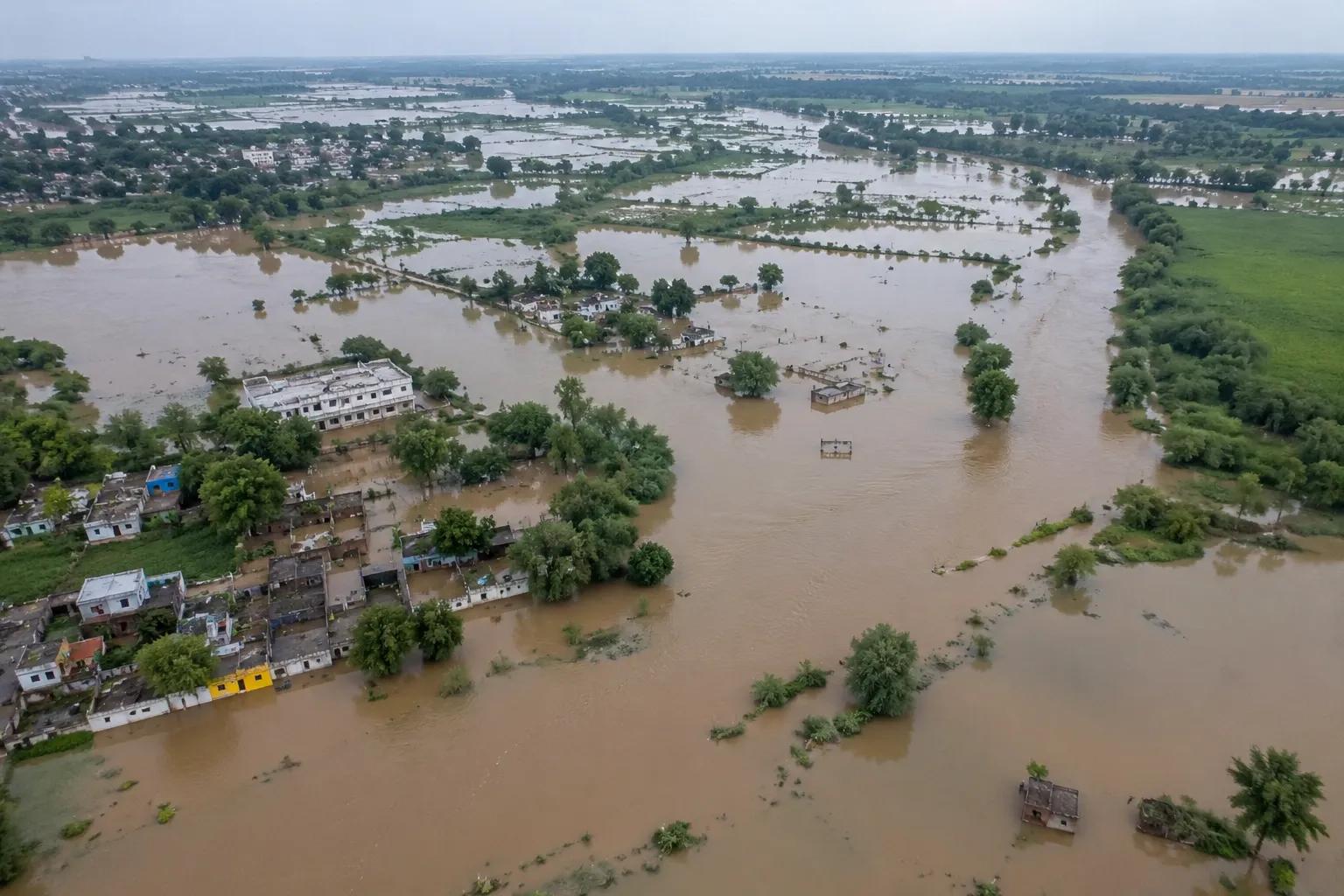
India's exposure to flood risk is growing. Rapid urbanisation, changing rainfall patterns, encroachment of natural floodplains, and inadequate drainage infrastructure are combining to make floods one of the country's most destructive and recurring natural hazards. Yet many infrastructure projects, urban development plans, and industrial sites are still designed without scientifically validated flood mapping and modelling — a gap that leads to catastrophic losses when extreme rainfall events occur.
Flood mapping and modelling is the scientific process of identifying flood-prone zones, simulating water flow behaviour during extreme rainfall events, and assessing the risk to land, infrastructure, and communities. Using GIS technology, hydrological data, and advanced hydraulic simulation software, flood modelling transforms raw rainfall and terrain data into actionable flood risk intelligence.
Bhoojal Survey provides professional flood mapping and modelling services across India — supporting government agencies, infrastructure developers, urban planners, and industrial project teams with accurate, data-driven flood risk assessment and watershed analysis.
Flood mapping and modelling is an integrated hydrological and geospatial methodology used to identify flood-vulnerable areas, simulate flood inundation extents, and quantify flood hazard levels across a given watershed or project area. It combines hydrological data collection, hydraulic modelling, and GIS-based spatial analysis into a comprehensive flood risk intelligence framework.
Flood mapping produces spatial outputs — maps showing which areas will flood, at what depth, and with what velocity — for defined storm return periods such as 25-year, 50-year, or 100-year flood events. Flood modelling simulates the hydrological and hydraulic processes governing water movement from rainfall to river channel overflow and surface inundation.
Core components of a flood mapping and modelling study include:
- Hydrological data collection — rainfall, streamflow, catchment area delineation
- Digital Elevation Model (DEM) processing for terrain and floodplain mapping
- Watershed delineation and drainage network analysis
- Hydraulic modelling of river channels and overland flow paths
- GIS-based flood inundation mapping for defined return period events
- Flood hazard and vulnerability assessment for the project zone
Why Flood Mapping and Modelling is Important
Across India, the consequences of unplanned development in flood-prone zones are well documented. Infrastructure damaged in annual monsoon floods, urban areas submerged due to inadequate stormwater drainage, and industrial facilities shut down by river overflow events — all represent preventable losses where proper flood risk mapping was absent at the project planning stage.
- Flood Risk Identification: Hydrological flood modelling precisely delineates which land parcels, road alignments, and structures fall within high, medium, and low flood hazard zones — essential information for project site selection and design.
- Infrastructure Protection: Bridges, culverts, embankments, highways, and industrial facilities designed using flood modelling outputs are sized correctly to withstand design flood events, preventing premature failure and reducing maintenance costs.
- Urban Planning and Watershed Management: GIS flood mapping enables city planners and development authorities to enforce flood zone regulations, preserve natural floodplain buffers, and design storm drainage systems with hydrologically validated capacity.
- Disaster Preparedness: Government flood control agencies and disaster management authorities use flood inundation maps to plan evacuation routes, identify shelter locations, and pre-position emergency response resources before monsoon seasons.
- Environmental and Public Safety: Flood vulnerability assessment protects communities, agricultural land, and ecosystems from the cascading effects of unmanaged flood events, including waterlogging, soil erosion, and groundwater contamination.
Methods Used in Flood Mapping and Modelling
Bhoojal Survey deploys a multi-method scientific approach to flood mapping and modelling, integrating field hydrological investigation, remote sensing, GIS analysis, and advanced hydraulic simulation to produce reliable flood risk outputs for diverse project types across India.
- GIS-Based Flood Mapping:
High-resolution Digital Elevation Models (DEM) derived from satellite imagery, LiDAR, or topographic survey data are processed in GIS to delineate watersheds, map drainage networks, and identify natural floodplain extents. Flood inundation zones are visualised as spatial maps for project planning and regulatory compliance.
- Hydrological and Hydraulic Modelling:
Rainfall-runoff modelling converts storm event data into flood discharge estimates for the watershed. These discharges are then routed through river channels and floodplains using hydraulic models (HEC-RAS, MIKE FLOOD, SWMM) to simulate water surface profiles, inundation depths, and flow velocities under design flood conditions.
- Satellite Remote Sensing Analysis:
Multi-temporal satellite imagery is analysed to map historical flood extents, identify surface water bodies, assess vegetation and land use patterns, and validate hydraulic model outputs against observed flood events.
- Watershed and Terrain Analysis:
Catchment morphology, slope, drainage density, and land use/land cover data are integrated to characterise watershed hydrology, estimate curve numbers, and develop accurate rainfall-runoff parameters for hydrological models.
- Flood Simulation and Inundation Modelling:
2D hydraulic flood simulations model complex overland flow patterns in urban areas and irregular terrain, producing detailed flood depth and velocity maps for infrastructure design, land use planning, and emergency management applications.
Bhoojal Survey conducts hydrogeological survey using SSRMPATS Instrument, GER DETECT, and PQWT at site for open well / borewell location — delivering advanced flood modelling and geospatial survey solutions with scientific hydrological investigation and flood risk analysis.
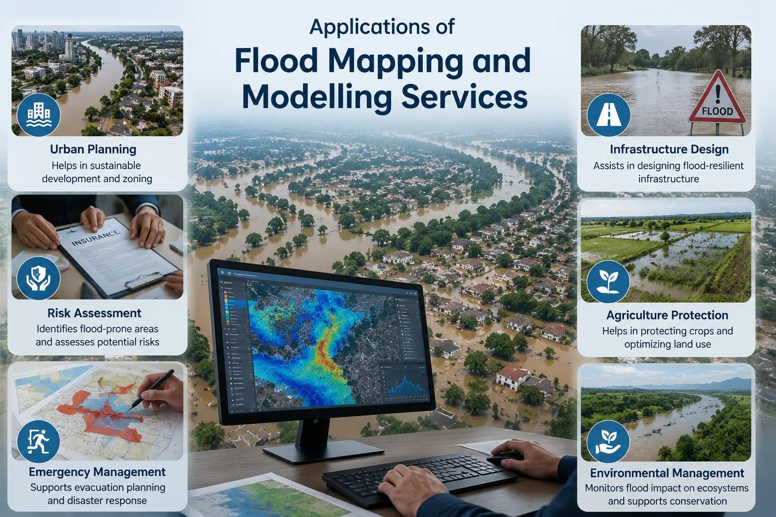
Applications of Flood Mapping and Modelling Services
Professional flood mapping and modelling services are required across a wide range of infrastructure, environmental, and government project categories in India. Bhoojal Survey has delivered flood risk assessment consultancy for the following application areas:
• Urban Flood Management Projects
• Irrigation & River Basin Management
• Smart City Infrastructure Planning
• Industrial Zone Flood Risk Assessment
• National & State Highway Projects
• NDMA Disaster Management Projects
• Mining Area Drainage Assessment
• Coastal & Estuarine Flood Modelling
For each application, Bhoojal Survey delivers a complete flood risk management consultancy package — from initial hydrological data collection through to GIS-based flood hazard maps, hydraulic model reports, and design flood recommendations aligned with Indian standard guidelines.
Why Choose Bhoojal Survey for Flood Mapping and Modelling Services
Bhoojal Survey is a trusted professional hydrological and geospatial consultancy providing flood risk assessment, watershed modelling, and GIS flood mapping services across India. Our team of experienced hydrologists, hydraulic modellers, and GIS specialists delivers scientifically rigorous flood analysis tailored to project-specific requirements.
- Experienced Hydrologists & GIS Experts: Our team brings multi-disciplinary expertise in hydrology, hydraulic engineering, remote sensing, and GIS analysis — ensuring technically comprehensive flood mapping and modelling outputs.
- Advanced Flood Modelling Technologies: We use industry-standard hydrological and hydraulic modelling software combined with high-resolution satellite and DEM data for accurate flood simulation and inundation mapping.
- Accurate Flood Risk & Watershed Analysis: Every project receives a rigorous scientific flood hazard assessment — from watershed delineation and rainfall frequency analysis to 2D hydraulic flood simulation and GIS risk mapping.
- Fast Reporting & Technical Consultancy: Our efficient project workflow ensures timely delivery of flood risk reports, model outputs, and GIS maps, supporting your project timelines and regulatory submission deadlines.
- Pan-India Hydrological Survey Services: From Himalayan river basins to peninsular dryland watersheds, Bhoojal Survey's flood modelling and risk assessment services cover India's full range of hydrological and climatic environments.
- Customised Flood Management Solutions: We design flood mapping and modelling programmes specifically matched to your project type, catchment characteristics, available data, and regulatory requirements — from single-site assessments to multi-basin watershed studies.
Conclusion
As India's urban populations grow and climate variability intensifies monsoon extremes, the demand for rigorous flood mapping and modelling will only increase. Infrastructure designed without hydrological flood analysis faces escalating risk of damage, disruption, and loss of life. Integrating professional flood risk assessment into the earliest stages of project planning is no longer optional — it is a fundamental requirement of responsible engineering and urban development.
Whether for a smart city drainage masterplan, a national highway alignment study, an industrial estate development, or a government flood control project, Bhoojal Survey's flood mapping and modelling services deliver the scientific rigour and geospatial intelligence your project needs to be built safely and compliantly.
Contact Bhoojal Survey for professional flood mapping and modelling services across India.
Frequently Asked Questions (FAQ)
1. What is flood mapping and modelling?
Flood mapping and modelling is a scientific process that uses hydrological data, hydraulic simulation, and GIS technology to identify flood-prone areas, predict flood inundation extents, and assess flood hazard levels for a given watershed or project site. It produces spatial flood risk maps and hydraulic model reports used in infrastructure design, urban planning, disaster management, and environmental assessment.
2. Why is flood risk assessment important for infrastructure projects in India?
India's infrastructure projects face significant flood risk due to monsoon rainfall extremes, riverine flooding, and urban stormwater challenges. Infrastructure designed without flood risk assessment is vulnerable to damage, premature failure, and disruption during flood events. Flood mapping and modelling ensures that structures are designed to withstand design flood events, reduces lifecycle costs, and protects public safety.
3. What technologies are used in flood mapping and modelling?
Key technologies include GIS software for spatial data processing and flood inundation mapping, hydrological modelling tools for rainfall-runoff analysis, hydraulic simulation software (such as HEC-RAS and MIKE FLOOD) for river channel and floodplain modelling, satellite remote sensing for terrain analysis and historical flood mapping, and Digital Elevation Models (DEM) for watershed delineation and terrain processing.
4. How does GIS help in flood mapping and risk assessment?
GIS is central to flood mapping because it integrates spatial data layers — terrain, land use, drainage networks, soil types, and infrastructure — into a unified analysis environment. GIS tools process DEM data to delineate watersheds, map drainage patterns, and produce flood inundation maps showing depth, extent, and velocity of flood events across the project area. The outputs support planning decisions, design standards, and regulatory compliance.
5. What types of projects require professional flood modelling services in India?
Flood modelling services are required for urban drainage masterplans, smart city infrastructure projects, national and state highway alignments, river basin management studies, industrial estate development, mining area drainage assessments, irrigation project planning, coastal zone development, and government disaster management and flood control programmes under NDMA, CWC, and state water resource department guidelines.