Flood Modeling in Andhra Pradesh
For any industrial, infrastructure, or solar project in Andhra Pradesh, it is crucial to analyze flood risk through simulation software to mitigate damage to structures and ensure worker safety during peak rainfall and floods.
A flood model, including Flood Modelling for solar project, can provide inputs on risk mitigation, such as effective drainage solutions to overcome losses during heavy rains.
We specialize in Hydrology report for solar project, Hydrology survey, calculating Maximum rainfall Intensity, determining HFL (High Flood Level), and more.
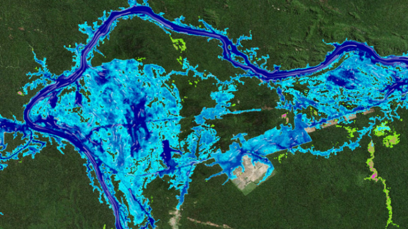
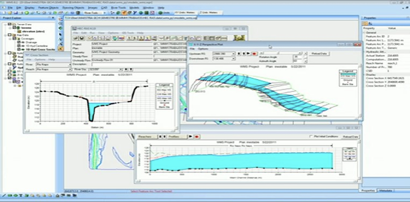
FLOOD MODELLING USING HEC RAS – SIMULATION SHOWING WATER AFFECTED ZONES IN CASE OF PEAK RAINFALL AND FLOODS
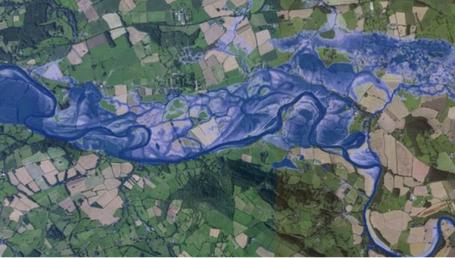
At Bhoojal Survey, we use digital terrain models with the latest software and technology, including meteorological data for peak rainfall analysis, geological studies for runoff calculation, and high-resolution contour maps to assess water flow and provide accurate flood models to overcome flood hazards in Andhra Pradesh cities like Visakhapatnam, Vijayawada, Guntur, Nellore, Kurnool, Rajahmundry, Tirupati, Kakinada, Anantapur, and Kadapa.
Our key service areas include:
- 1. Dam failure impact assessment
- 2. Flood impact assessment and development feasibility
- 3. Catchment management studies
- 4. Floodplain risk management studies – damage and safety analysis
- 5. Flood mitigation option investigations
- 6. Flood warning systems
- 7. Historical flood analysis and stream gauging
- 8. Sizing major hydraulic structures such as bridges and culverts
- 9. Hydrographic survey
- 10. Urban and rural catchment flood investigations
- 11. 3D flood rendering and animation
Industrial Projects Done by Bhoojal Survey in Andhra Pradesh
Bhoojal Survey has successfully completed flood modeling projects for various industrial and infrastructure initiatives, including solar projects, across major cities in Andhra Pradesh. Our expertise in Flood Modelling for solar project, Hydrology report for solar project, Hydrology survey, Maximum rainfall Intensity, HFL, and High Flood level has helped mitigate flood risks for major clients. Some notable projects include:
- Flood risk assessment and modeling for a solar power plant in Visakhapatnam, incorporating Hydrology survey and Maximum rainfall Intensity calculations to ensure site safety.
- Comprehensive flood simulation and Hydrology report for solar project in Vijayawada, including HFL determination for urban infrastructure development.
- Flood impact analysis for a renewable energy solar project in Guntur, using advanced models to predict High Flood level scenarios.
- Dam failure and floodplain modeling for an industrial complex in Nellore, aiding in emergency preparedness with Hydrology survey data.
- Flood mitigation strategies for a solar farm in Kurnool, utilizing HEC-RAS simulations to assess Maximum rainfall Intensity and runoff.
- Catchment management and 3D flood rendering for a manufacturing plant in Rajahmundry, focusing on HFL and flood risk reduction.
- Hydrology report for solar project and flood modeling in Tirupati, ensuring compliance and safety during peak rainfall.
- Flood warning system development for an infrastructure project in Kakinada, including calculations for High Flood level.
- Urban catchment flood investigations for a solar installation in Anantapur, with detailed Hydrology survey.
- Historical flood analysis for a renewable energy project in Kadapa, predicting future risks based on Maximum rainfall Intensity data.
Flood modeling approaches include
Hydrologic modeling: Uses computer tools to analyze water flow in a river or stream system
Hydraulic modeling: Uses the results of hydrologic analysis to simulate water movement during a flood
Flood modeling has evolved into a crucial instrument in the management of flood risk, assisting academics and professionals in comprehending and predicting the behavior of floods, as well as making defensible choices to lessen their effects.
FAQs: Flood Modeling in Andhra Pradesh
What is flood modeling?
Flood modeling is the process of using computer simulations to predict the extent and impact of flooding in a given area. These models can forecast flood depths, velocities, and extents based on various input data such as rainfall, topography, and land use, including for solar projects in Andhra Pradesh.
Why is flood modeling important for solar projects?
Flood modeling, including Flood Modelling for solar project, is crucial for disaster preparedness and mitigation. It helps in understanding flood risk, planning drainage, and ensuring the longevity of solar installations by considering HFL and Maximum rainfall Intensity.
What data is required for flood modeling?
Flood modeling requires various data inputs, such as: Topographic data, Hydrological data for Hydrology survey, Land use and land cover data, Soil type and infiltration rates, Meteorological data for Maximum rainfall Intensity.
How accurate