Every year, thousands of borewells across India are drilled at the wrong location — and most of them fail. The result is wasted investment, delayed projects, and a chronic water shortage that could have been prevented. The solution lies in hydrogeological exploration: a scientific, data-driven approach to understanding what lies beneath the surface before a single drill bit touches the ground.
Hydrogeological exploration combines field investigation, geophysical surveys, aquifer mapping, and groundwater analysis to identify exactly where groundwater exists, how deep it is, and how sustainably it can be extracted. For industrial developers, irrigation planners, infrastructure companies, and government water authorities, professional groundwater exploration services are no longer optional — they are essential.
At Bhoojal Survey, we deliver end-to-end hydrogeological investigation services backed by advanced instruments, experienced hydrogeologists, and a proven methodology developed across hundreds of projects in India.
What is Hydrogeological Exploration?
Hydrogeological exploration is the scientific process of studying subsurface geological formations to locate, assess, and characterize groundwater resources. It integrates principles of geology, hydrology, and geophysics to map aquifers — the underground layers that store and transmit water — and evaluate their potential for sustainable extraction.
Unlike traditional methods that rely on guesswork or local knowledge, hydrogeological groundwater survey uses measurable data — electrical resistivity, terrain analysis, satellite imagery, and borehole logs — to produce a reliable picture of the subsurface. The output is a technical report that guides safe, successful borewell placement and long-term groundwater management.
Key components of a hydrogeological investigation include:
- Aquifer identification and depth estimation
- Groundwater recharge zone mapping
- Subsurface water investigation through geophysical methods
- Groundwater availability analysis and yield prediction
- Scientific reporting for regulatory or project planning purposes
Why Hydrogeological Exploration Is Important
India is facing a deepening groundwater crisis. According to CGWB data, over 16% of assessed groundwater blocks are already over-exploited. In this context, scientific groundwater exploration is not just a technical exercise — it is a critical investment in water security.
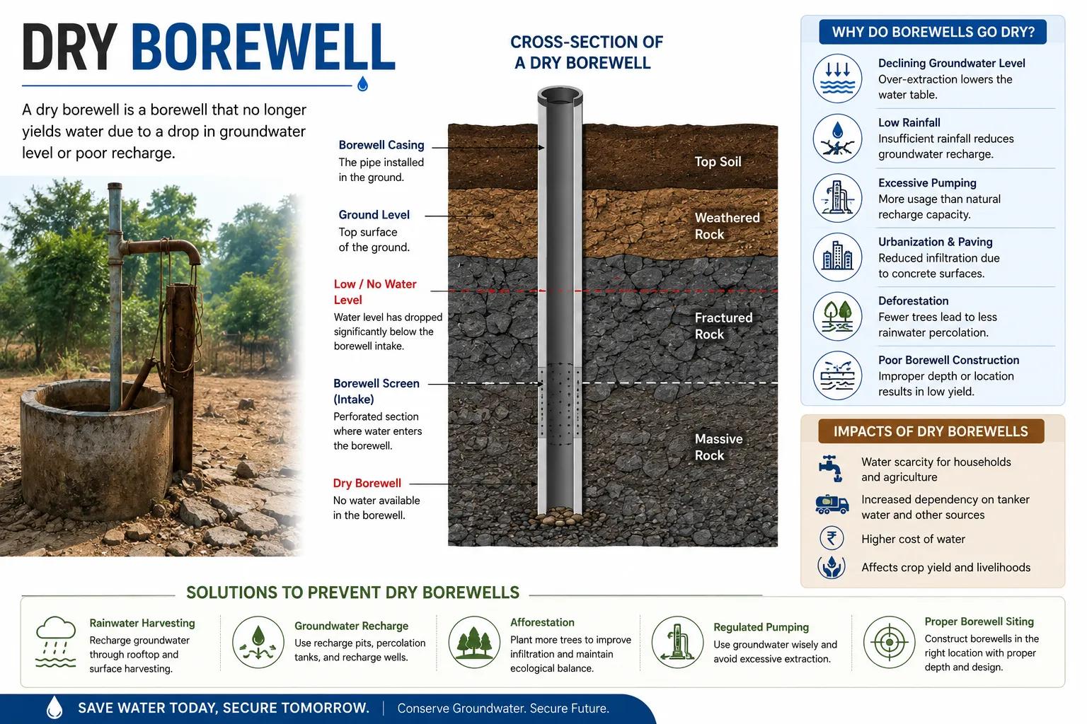
Reduces Dry Borewell Risk
Without proper aquifer analysis services, drilling is a gamble. Professional hydrogeological investigation identifies productive zones, dramatically lowering the risk of dry or low-yield borewells.
Enables Accurate Groundwater Resource Assessment
Groundwater resource assessment quantifies how much water is available, how fast it recharges, and whether it can sustain your project's demand over time.
Supports Industrial and Agricultural Planning
Large-scale water users — factories, mines, irrigation schemes — need groundwater availability analysis to plan their operations without causing environmental damage or legal violations.
Improves Groundwater Recharge Assessment
Understanding where recharge happens helps design artificial recharge structures and rainwater harvesting systems that replenish aquifers sustainably.
Meets Regulatory Requirements
Government departments and environmental clearances increasingly require hydrogeological reports before granting permission for large-scale groundwater extraction.
Methods Used in Hydrogeological Exploration
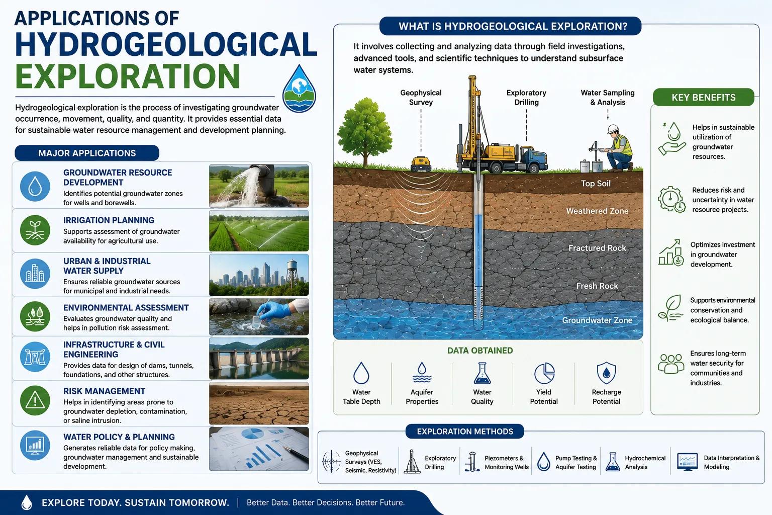
Modern hydrogeological exploration services draw on a range of complementary techniques. At Bhoojal Survey, we combine field investigation with state-of-the-art instruments to deliver reliable results.
Electrical Resistivity Survey
This is the most widely used geophysical groundwater investigation technique in India. By measuring how strongly the ground resists electrical current, resistivity survey for groundwater reveals the depth, thickness, and water-bearing capacity of aquifer layers with high accuracy.
Advanced Instrument-Based Survey
Bhoojal Survey conducts hydrogeological surveys using SSRMPATS Instrument, GER DETECT, and PQWT at site for open well and borewell location identification. These instruments provide multi-layer subsurface profiling that is far more reliable than traditional methods.
Geological and Terrain Analysis
Surface geology, rock type, slope, drainage patterns, and land use are analysed to understand the natural conditions that control groundwater occurrence and movement.
Satellite Remote Sensing and GIS Mapping
Satellite data combined with GIS mapping identifies lineaments, fracture zones, and recharge areas over large territories — essential for regional aquifer mapping surveys and basin-scale groundwater planning.
Hydrogeological Field Investigation
On-site data collection includes soil sampling, water table measurement, pumping tests, and aquifer parameter estimation. This field data validates instrument readings and forms the basis of the technical report.
Bhoojal Survey offers advanced groundwater and geophysical survey solutions combined with scientific groundwater investigation and aquifer analysis — giving clients the most accurate subsurface picture possible.
Applications of Hydrogeological Exploration
Hydrogeological investigation is relevant across every sector that depends on reliable water supply.
Common applications include:
Agricultural Irrigation Projects
Identifying productive aquifers for irrigation borewells and designing groundwater recharge structures to sustain crop water demand.
Industrial Groundwater Supply
Assessing aquifer yield and water quality for manufacturing, processing, and cooling water requirements.
Infrastructure and Mining Projects
Dewatering planning, slope stability assessment, and groundwater impact studies for tunnels, roads, and mines.
Commercial and Real Estate Development
Ensuring reliable groundwater supply and drainage conditions for large commercial complexes and townships.
Government Water Resource Management
Supporting government groundwater resource management projects and State Water Departments in aquifer management plans.
Borewell Drilling and Recharge Projects
Providing hydrogeological investigation for borewell drilling to identify optimal drilling depths and productive zones, and designing recharge wells.
Why Choose Bhoojal Survey for Hydrogeological Exploration
As a leading hydrogeological consultancy services provider operating across India, Bhoojal Survey brings together the right people, technology, and methodology to deliver results you can rely on.
- Experienced hydrogeologists and groundwater experts with deep field knowledge across variedgeological terrains
- Advanced geophysical instruments including SSRMPATS, GER DETECT, and PQWT for multi-layersubsurface profiling
- Accurate aquifer mapping and groundwater analysis with detailed technical reporting
- Fast project turnaround with site visits, instrument surveys, and report delivery
- Pan-India groundwater exploration services covering industrial, agricultural, and infrastructureprojects
- Customised groundwater management solutions tailored to each project's hydrogeological conditions
- Transparent methodology aligned with CGWB guidelines and Ministry of Jal Shakti standards
Conclusion
Hydrogeological exploration is the foundation of every successful groundwater project. Whether you are planning a new industrial facility, expanding an irrigation network, or developing a township, understanding your subsurface water resources before drilling saves money, reduces risk, and ensures long-term water security.
Professional groundwater investigation services from Bhoojal Survey give you the scientific certainty you need — so you can drill with confidence, plan with accuracy, and manage water sustainably for the future.
Contact Bhoojal Survey today for professional hydrogeological exploration and groundwater investigation services across India.
Frequently Asked Questions (FAQs)
Q1. What is hydrogeological exploration?
Hydrogeological exploration is the scientific investigation of subsurface geological formations to locate aquifers, assess groundwater availability, and determine sustainable extraction rates. It uses geophysical methods, field surveys, and data analysis to produce an accurate picture of underground water resources.
Q2. Why is hydrogeological investigation important before drilling a borewell?
Without proper investigation, borewell drilling is based on guesswork. A scientific hydrogeological survey identifies the exact depth, location, and yield potential of aquifers — dramatically reducing the risk of dry borewells and wasted drilling costs.
Q3. What methods are used in groundwater exploration?
Key methods include electrical resistivity survey, geological terrain analysis, satellite remote sensing and GIS mapping, aquifer mapping, and hydrogeological field investigation. Advanced instruments like SSRMPATS, GER DETECT, and PQWT are used for precise subsurface profiling.
Q4. How does resistivity survey help in groundwater detection?
Resistivity survey measures how strongly soil and rock layers resist electrical current. Water-bearing formations have distinctly lower resistivity than dry rock, allowing hydrogeologists to identify aquifer depth, thickness, and water content with high accuracy.
Q5. What is aquifer mapping and why is it important?
Aquifer mapping is the process of delineating the boundaries, depth, and properties of underground water-bearing formations. It is essential for planning sustainable groundwater extraction, designing recharge structures, and managing water resources at basin scale.
Q6. Can hydrogeological exploration help assess groundwater recharge?
Yes. Groundwater recharge assessment is a core part of hydrogeological exploration. It identifies natural recharge zones and helps design artificial recharge structures such as check dams, percolation ponds, and injection wells.
Q7. Who needs hydrogeological exploration services?
Industrial developers, irrigation project planners, infrastructure and mining companies, commercial real estate developers, borewell drilling contractors, and government water resource departments all benefit from professional hydrogeological investigation services.
Q8. Why choose Bhoojal Survey for hydrogeological exploration in India?
Bhoojal Survey combines experienced hydrogeologists, advanced geophysical instruments, and a proven scientific methodology to deliver accurate, reliable groundwater exploration services across India — from site investigation to final technical reporting.