Introduction
Water is the foundation of every successful project — industrial, agricultural, or commercial. Yet, drilling a borewell without a proper borewell site survey is one of the costliest mistakes project developers make. A
failed or dry borewell can waste lakhs of rupees and delay critical project timelines.
A borewell site survey is a systematic, science-driven investigation that identifies the most productive groundwater zones beneath the earth's surface before a single drill touches the ground. Using advanced geophysical survey for borewell techniques, hydrogeological assessments, and remote sensing data, expert consultants precisely determine where, how deep, and at what yield groundwater can be reliably extracted.
At Bhoojal Survey, we have guided hundreds of industrial, infrastructure, and agricultural projects across India toward successful borewell drilling through rigorous groundwater survey for borewell and hydrogeological investigation. This article explains what a borewell site survey involves, why it is indispensable, and how our professional services deliver measurable results.
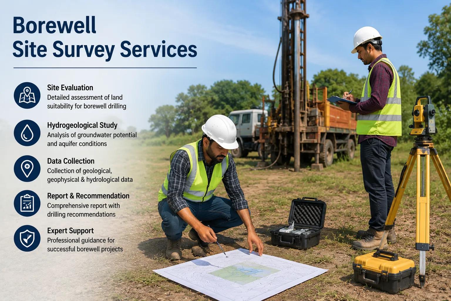
What is a Borewell Site Survey?
A borewell site survey is a pre-drilling groundwater investigation conducted by certified hydrogeologists and geophysical experts to scientifically identify the optimal location for borewell drilling. It combines geological mapping, resistivity measurements, remote sensing data, and hydrogeological analysis to pinpoint underground aquifer zones with the highest potential for sustainable water yield.
Unlike traditional water-dowsing or guesswork-based methods, a scientific borewell location survey provides quantitative data about subsurface geology, groundwater depth, aquifer thickness, and expected water yield. This enables project developers and drilling companies to drill with precision, confidence, and significantly reduced financial risk.
Why Is a Borewell Site Survey Important?
Skipping a scientific groundwater detection survey before borewell drilling exposes project developers to serious risks:
■ Risks Without Survey
■ Benefits With Survey
- Dry or failed borewell drilling
- Wasted drilling expenses (■3–15 lakhs per borewell)
- Incorrect depth estimation leading to poor yield
- Irreversible geological disturbance
- Scientifically identified borewell location
- Higher drilling success rate (80–95%)
- Accurate depth and yield estimation
- Sustainable long-term groundwater availability
For large industrial parks, infrastructure projects, and commercial complexes where reliable water supply is mission-critical, a professional borewell drilling site investigation is not optional — it is essential.
Methods Used in Borewell Site Survey
Bhoojal Survey employs a multi-method approach to hydrogeological survey for borewell that ensures comprehensive subsurface evaluation:
Hydrogeological Investigation
Detailed study of the area's rock types, formations, soil profiles, drainage patterns, and historical groundwater data to understand the overall groundwater regime.
Earth Resistivity Survey (ERS)
The primary geophysical survey for borewell technique. Electrical resistivity tomography (ERT) measures subsurface resistance to identify water-bearing fractures, fissures, and aquifer zones at varying depths.
Satellite Remote Sensing Analysis
High-resolution satellite imagery and terrain analysis to identify lineaments, fault zones, and geological structures associated with groundwater accumulation.
Groundwater Aquifer Mapping
Systematic aquifer detection survey mapping to delineate the lateral extent, depth, and thickness of productive aquifer layers.
VES (Vertical Electrical Sounding)
Depth-specific resistivity measurements to construct a vertical electrical log of subsurface formations and identify the most productive drilling depth.
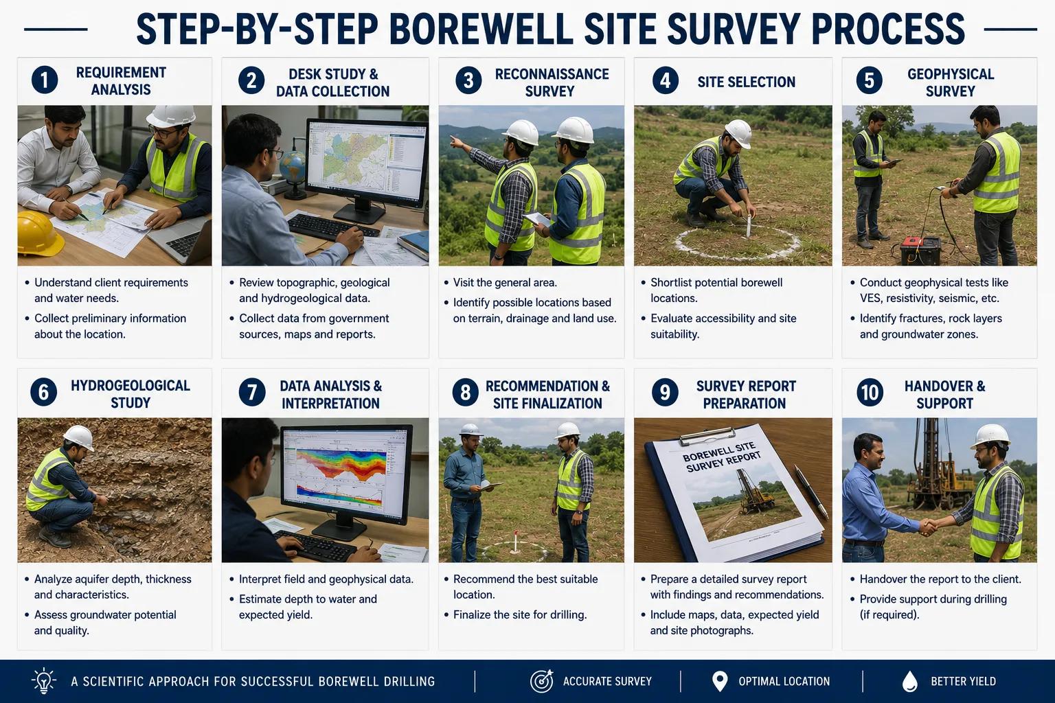
Step-by-Step Borewell Site Survey Process
1 Initial Site Inspection & Data Collection
Field visit by senior hydrogeologists; collection of existing geological maps, previous borewell logs, and topographic data of the survey area.
2 Geological & Hydrogeological Assessment
Evaluation of rock formations, soil type, land-use patterns, drainage basins, and recharge zones to develop a preliminary groundwater model.
3 Geophysical Resistivity Survey
Deployment of resistivity survey instruments across planned transects to capture detailed subsurface electrical data and map aquifer boundaries.
4 Groundwater Aquifer Detection & Analysis
Processing and interpretation of resistivity data combined with hydrogeological findings to identify the most productive borewell points.
5 Scientific Borewell Location Identification
Precise GPS-marked identification of optimal borewell drilling locations with recommended depth, casing design, and expected yield range.
6 Technical Hydrogeological Report Preparation
Comprehensive written report including survey methodology, interpreted data, aquifer maps, borewell location coordinates, and drilling recommendations.
Industries & Projects That Require Borewell Site Survey
Groundwater is a critical resource for a wide spectrum of sectors. Bhoojal Survey provides professional borewell site survey services for:
Sectors Served by Bhoojal Survey
- Manufacturing & Processing Industries — continuous process water, cooling towers, utilities
- Infrastructure & Highway Projects — construction water supply, dust suppression, labour camps
- Commercial & Residential Complexes — apartment townships, IT parks, hotels, hospitals
- Industrial Parks & Special Economic Zones (SEZ) — large-scale groundwater planning
- Agricultural Irrigation Projects — farm borewells, micro-irrigation, drip systems
- Mining & Quarrying Operations — dewatering surveys, process water supply
- Government & Public Infrastructure — schools, municipal water supply, defence establishments
- Real Estate Development Projects — pre-construction groundwater feasibility studies
Challenges Without a Professional Borewell Survey
Many project developers attempt to drill borewells based on local advice, incomplete geological maps, or visual field inspection alone. This approach consistently leads to preventable failures:
Dry Borewell Risk: Without a scientific groundwater detection survey, borewells frequently hit only dry rock formations, resulting in complete capital loss.
Incorrect Drilling Location: Surface conditions rarely reflect subsurface geology. A seemingly favourable location may overlie impermeable hard rock with no productive aquifer.
Depth Miscalculation: Without resistivity data, drillers often stop short of productive aquifer zones or drill unnecessarily deep, escalating costs.
Groundwater Quality Issues: Inadequate hydrogeological assessment can lead to drilling into saline, contaminated, or low-yield aquifer zones.
Regulatory & Legal Complications: CGWA (Central Ground Water Authority) regulations increasingly mandate hydrogeological reports for large-scale groundwater extraction, especially in notified/over-exploited areas.
How Bhoojal Survey Can Help You
Choosing the right hydrogeological consultant is critical. Here is how Bhoojal Survey delivers measurable value to every project we undertake:
01 End-to-End Groundwater Consultancy
From initial site reconnaissance to final technical report, Bhoojal Survey manages the complete borewell drilling survey process — so you never have to coordinate multiple agencies.
02 Experienced Hydrogeologists On-Site
Our team of certified hydrogeologists and geophysicists has conducted over hundreds of surveys across diverse geological terrains including Deccan Traps, alluvial plains, crystalline basement rocks, and coastal sedimentary formations.
03 Advanced Multi-Instrument Technology
We deploy SSRMPATS, GER DETECT, PQWT, and ERT instruments simultaneously for cross-validated, high-confidence borewell water source investigation.
04 Customised Industry-Specific Solutions
Whether it's a 500-acre industrial park needing multiple borewells or a single commercial building requiring one reliable borewell, we customise our groundwater investigation services to match your exact project scale and budget.
05 CGWA-Compliant Hydrogeological Reports
Our detailed reports comply with Central Ground Water Authority (CGWA) and Ministry of Jal Shakti requirements — essential for NOC applications and large-scale groundwater extraction permissions.
06 Pan-India Project Coverage
Bhoojal Survey operates across all major states in India, offering rapid site mobilisation for urgent project timelines in industrial corridors, infrastructure development zones, and agricultural regions.
07 Post-Survey Drilling Advisory
Beyond site survey, we provide borewell design recommendations — casing depth, pump selection, and yield testing advisory — ensuring complete drilling success.
08 Transparent Pricing & Timely Delivery
We provide clear scope-of-work proposals, fixed survey timelines, and comprehensive reports delivered within committed timeframes — no hidden costs.
Why Choose Bhoojal Survey?
Bhoojal Survey is a trusted name in professional groundwater exploration consultancy across India. Our reputation is built on scientific rigour, field expertise, and a proven track record of successful borewell site identification for diverse project types.
Our Key Differentiators
- Certified & experienced hydrogeologists and geophysical survey experts
- Advanced SSRMPATS, GER DETECT, and PQWT groundwater detection instruments
- Pan-India consultancy for industrial, infrastructure, and agricultural projects
- CGWA and Ministry of Jal Shakti compliant hydrogeological investigation reports
- Transparent, scientific, and GPS-verified borewell location recommendations
- High drilling success rates across hard rock, alluvial, and coastal terrains
- End-to-end service: survey, report, drilling advisory, and post-survey support
- Competitive pricing with clear deliverables and committed project timelines
Conclusion
A borewell site survey is not an added cost — it is a strategic investment that dramatically increases the probability of drilling a productive, sustainable borewell. Scientific groundwater detection services eliminate guesswork, reduce drilling expenditure, and ensure long-term water security for your project.
Whether you are developing an industrial park, constructing a commercial complex, irrigating agricultural land, or building critical infrastructure, Bhoojal Survey brings the expertise, technology, and scientific methodology to identify the right borewell location — accurately, reliably, and within your project schedule.
Ready to Locate Groundwater with Precision?
Contact Bhoojal Survey for professional borewell site survey and groundwater investigation services across India. Our expert hydrogeologists are ready to conduct a scientific survey at your project site — industrial, agricultural, commercial, or infrastructure.
Frequently Asked Questions (FAQs)
Q: What is a borewell site survey?
A: A borewell site survey is a scientific pre-drilling investigation using hydrogeological assessment and geophysical resistivity survey methods to identify the most productive groundwater location, depth, and expected yield for borewell drilling.
Q: Why is a groundwater survey required before borewell drilling?
A: Without a scientific groundwater survey, the risk of drilling a dry or low-yield borewell is very high — often exceeding 60-70% in hard rock terrains. A professional borewell site survey reduces this risk to under 5–20%, saving significant drilling costs.
Q: How is the borewell location detected scientifically?
A: Borewell location is detected using Earth Resistivity Survey (ERS), Vertical Electrical Sounding (VES), and hydrogeological mapping. These methods identify underground fractures, aquifer zones, and water-bearing formations to pinpoint the optimal drilling point.
Q: What technology does Bhoojal Survey use for borewell site survey?
A: Bhoojal Survey uses SSRMPATS Instrument, GER DETECT, PQWT multi-channel water detector, and resistivity tomography equipment for scientific borewell groundwater detection, combined with GIS-based satellite remote sensing analysis.
Q: How accurate is hydrogeological borewell detection?
A: With professional geophysical survey and hydrogeological investigation, borewell drilling success rates typically range from 80–95%, compared to 30–40% without any scientific survey.
Q: How long does a borewell site survey take?
A: Depending on the project size and site complexity, a standard borewell site survey typically takes 1–3 days for field survey activities. The complete technical report is usually delivered within 5–7 working days after field work completion.
Q: Does Bhoojal Survey provide services across all states in India?
A: Yes. Bhoojal Survey provides pan-India borewell site survey and groundwater investigation consultancy services for industrial, agricultural, infrastructure, and commercial projects across all major states and Union Territories of India.
Q: Is a hydrogeological report required for CGWA approval?
A: Yes. The Central Ground Water Authority (CGWA) mandates hydrogeological investigation reports for groundwater extraction NOC applications, especially in notified, over-exploited, or critical groundwater assessment units. Bhoojal Survey prepares CGWA-compliant hydrogeological reports for such regulatory requirements.