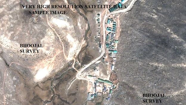
satellite topographic survey
Land elevation errors in infrastructure project planning are among the most expensive mistakes an engineer or developer can make. A road alignment designed on inaccurate contour data, a drainage system sized for the wrong catchment slope, or a mining bench layout based on unreliable terrain models — each represents avoidable cost overruns and design failures. Satellite topographic survey eliminates these risks by delivering precision terrain data across large project areas rapidly, cost-effectively, and with the spatial accuracy that modern infrastructure design demands.
Satellite topographic survey uses high-resolution satellite imagery, digital elevation modelling, and GIS-based spatial analysis to map terrain features, contour lines, slope gradients, drainage networks, and land cover across project zones. It provides the foundational terrain intelligence needed for highway design, mining development, watershed management, urban planning, and infrastructure layout — all from remotely sensed data processed to precise engineering standards.
Bhoojal Survey provides professional satellite topographic survey and GIS terrain mapping services across India — supporting infrastructure developers, EPC contractors, government agencies, and mining companies with accurate, reliable, and project-ready topographic data.
What is Satellite Topographic Survey
A satellite topographic survey is a geospatial mapping process that uses satellite-derived imagery and elevation data to produce detailed terrain maps, digital elevation models (DEM), contour maps, and land surface analysis outputs for project planning and engineering design. It combines remote sensing satellite data with GIS processing to generate accurate spatial representations of the earth's surface without requiring ground crews to traverse every metre of the survey area.
Modern satellite topographic surveys utilise high-resolution optical and radar satellite imagery — including data from ISRO's Cartosat series, ESA's Sentinel platforms, and commercial high-resolution satellites — processed in GIS software to produce terrain products accurate to sub-metre horizontal resolution and metre-level vertical precision, depending on the satellite system and processing methodology used.
Core deliverables of a satellite topographic survey include:
- Digital Elevation Model (DEM) — continuous terrain elevation surface across the project area
- Contour map — topographic contour lines at defined vertical intervals (0.5m to 5m as required)
- Slope and aspect maps — terrain gradient and orientation analysis for engineering and drainagedesign
- Drainage network map — automatically delineated stream channels and watershed boundaries
- Land use and land cover map — surface feature classification from satellite imagery
- 3D terrain visualisation — perspective views for project planning and stakeholder presentation
Why Satellite Topographic Survey is Important
Reliable terrain data is the foundation of every infrastructure, mining, and land development project. Decisions made on inaccurate or low-resolution topographic data — from alignment selection to drainage design to earthwork estimation — cascade into costly engineering changes, regulatory delays, and construction overruns. Satellite topographic surveys provide the terrain accuracy these decisions require at a fraction of the time and cost of traditional ground survey methods for large project areas.
- Accurate Terrain and Contour Mapping: High-resolution satellite DEMs provide terrain elevation data at spatial resolutions from 30 metres (SRTM) down to sub-metre (commercial satellites), enabling contour mapping at engineering-grade precision across project areas of any size.
- Infrastructure Planning Support: Highway alignments, railway routes, pipeline corridors, and transmission line layouts are optimised using satellite topographic data to minimise earthwork volumes, avoid unstable terrain, and reduce crossing of drainage features.
- Land Development Analysis: Industrial estate layouts, township planning, and commercial development sites are graded and designed using satellite terrain data to identify cut-and-fill requirements, drainage outlets, and natural terrain constraints.
- Environmental and Watershed Planning: Watershed delineation, flood risk mapping, erosion susceptibility assessment, and environmental impact studies all rely on accurate topographic data derived from satellite survey to model hydrological and terrain processes correctly.
- Reducing Project Planning Errors: Satellite topographic surveys catch terrain-related design problems at the planning stage — before construction begins — avoiding the far greater costs of mid-construction design modifications and earthwork revisions.
Methods Used in Satellite Topographic Survey
Bhoojal Survey combines satellite remote sensing, GIS processing, and field verification to deliver satellite topographic survey products that meet engineering-grade accuracy standards for infrastructure, mining, and environmental projects across India.
- GIS-Based Terrain Mapping:
High-resolution satellite imagery and elevation datasets are processed in GIS software to produce topographic maps, contour layers, terrain slope and aspect maps, and 3D terrain models. GIS processing enables rapid, consistent terrain analysis across large project areas that would take months to cover by traditional ground survey.
- Remote Sensing Analysis:
Multi-spectral and panchromatic satellite imagery is processed for land use classification, change detection, surface feature mapping, and vegetation analysis. Radar satellite data (SAR) provides terrain elevation data even through cloud cover — critical for projects in India's monsoon-affected regions.
- Digital Elevation Modelling:
Satellite stereo-pair imagery and radar interferometry (InSAR) data are processed to generate high-resolution Digital Elevation Models. These DEMs are the numerical foundation for all terrain analysis products — from contour maps to slope stability assessments to volumetric earthwork calculations.
- Satellite Imagery Interpretation:
Trained geospatial analysts interpret satellite imagery to identify geological features, drainage anomalies, land use boundaries, infrastructure corridors, and terrain hazard indicators relevant to project planning decisions.
- Contour and Landform Analysis:
Processed DEM data is converted into precise contour maps at project-specified vertical intervals. Landform classification identifies ridges, valleys, plains, and dissected terrain units, supporting alignment optimisation and land development planning across the project zone.
Bhoojal Survey conducts hydrogeological survey using SSRMPATS Instrument, GER DETECT, and PQWT at site for open well / borewell location — delivering advanced satellite and geospatial survey solutions with scientific terrain investigation and spatial analysis.
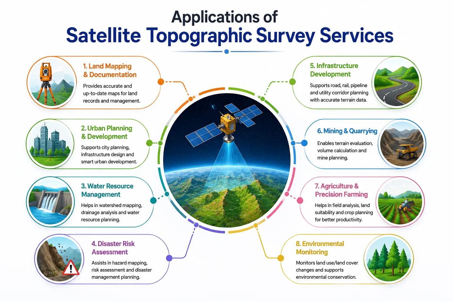
Applications of Satellite Topographic Survey Services
Professional satellite topographic survey services are applied across a broad range of infrastructure, industrial, environmental, and government project sectors in India. Bhoojal Survey has delivered GIS terrain mapping and topographic analysis for the following application areas:
• National & State Highway Alignment Studies
• Watershed Management & Flood Risk Studies
• Railway Route Planning & Corridor Analysis
• Industrial Estate & SEZ Layout Planning
• Open-Cast Mining & Quarry Development
• Pipeline & Transmission Line Corridors
• Smart City Infrastructure Planning
• Government Land Development & Revenue Survey
For each application, Bhoojal Survey delivers a complete satellite topographic survey package — from raw satellite data acquisition and DEM processing through to final GIS-ready terrain products, contour maps, and technical reports formatted for engineering design, regulatory submission, and project planning use.
Why Choose Bhoojal Survey for Satellite Topographic Survey Services
Bhoojal Survey is a professional geospatial and topographic consultancy providing satellite terrain mapping, GIS analysis, and remote sensing services across India. Our team combines satellite data processing expertise with hydrogeological and infrastructure survey experience to deliver integrated terrain intelligence for complex projects.
- Experienced Geospatial and Survey Experts: Our GIS and remote sensing specialists have extensive experience processing satellite topographic data for highway, mining, watershed, and urban development projects across India's diverse terrain environments.
- Advanced Satellite Mapping Technologies: We work with high-resolution optical and radar satellite datasets — including ISRO Cartosat, Sentinel-1/2, and commercial satellite imagery — processed using industry-standard GIS and DEM analysis software.
- Accurate Terrain and Contour Analysis: Every satellite topographic survey project delivers DEM products, contour maps, and terrain analysis outputs validated against available ground control data for engineering-grade accuracy assurance.
- Fast Reporting and Technical Consultancy: Satellite topographic survey products are delivered efficiently — without the weeks-long fieldwork mobilisation that traditional ground survey requires for large project areas.
- Pan-India Geospatial Survey Services: Our satellite topographic survey capabilities cover the full range of Indian terrain — from Himalayan mountain ranges to peninsular plateaus, coastal plains to desert environments — without geographical or seasonal access limitations.
- Customised Topographic Investigation Solutions: We design satellite survey programmes precisely matched to your project area, required accuracy, deliverable format, and engineering application — from preliminary alignment studies to detailed design-level terrain models.
Conclusion
In an era of accelerating infrastructure development across India, the demand for fast, accurate, and cost-effective terrain data has never been higher. Satellite topographic survey meets this demand by combining the spatial coverage of satellite remote sensing with the analytical power of modern GIS processing — delivering terrain intelligence across project areas of any size, in any location, at engineering-grade precision.
Whether your project is a national highway alignment in Central India, an open-cast mine development in Jharkhand, a smart city masterplan in Rajasthan, or a watershed management study in the Western Ghats, Bhoojal Survey's satellite topographic survey and GIS terrain mapping services provide the foundational spatial data your project needs to proceed with confidence.
Contact Bhoojal Survey for professional satellite topographic survey and GIS mapping services across India.
Frequently Asked Questions (FAQ)
1. What is satellite topographic survey and how does it work?
Satellite topographic survey is a geospatial mapping process that uses satellite-derived imagery and elevation data to produce detailed terrain maps, digital elevation models, contour maps, and land surface analysis outputs. It works by processing high-resolution satellite imagery and radar data in GIS software to extract precise terrain elevation values across the project area, which are then used to generate contour maps, slope models, drainage networks, and 3D terrain visualisations for engineering and planning applications.
2. Why is terrain mapping important for infrastructure projects in India?
Accurate terrain mapping is the foundation of every infrastructure project. Highway alignments, railway routes, drainage systems, and building layouts must be designed using precise topographic data to optimise earthwork volumes, avoid unstable terrain, manage drainage correctly, and minimise construction costs. Projects designed on inaccurate or outdated terrain data face expensive mid-construction design changes. Satellite topographic survey delivers engineering-grade terrain data rapidly and cost-effectively across project areas of any scale.
3. How does GIS help in satellite topographic surveys?
GIS (Geographic Information Systems) is the core technology used to process, analyse, and present satellite topographic survey data. GIS software processes raw satellite elevation data to generate DEMs, contour maps, slope and aspect layers, and drainage network maps. It enables spatial analysis of terrain features, integration of multiple data layers, production of publication-quality maps, and export of terrain data in formats compatible with engineering design software such as AutoCAD Civil 3D and 12D.
4. What is the accuracy of satellite topographic survey for engineering projects?
Satellite topographic survey accuracy depends on the satellite system and processing methodology. Freely available DEMs such as SRTM provide approximately 30-metre horizontal resolution and around 5-10 metre vertical accuracy — suitable for preliminary planning. Commercial high-resolution satellite DEMs achieve sub-metre horizontal resolution and 1-3 metre vertical accuracy. For engineering design requiring higher accuracy, satellite survey is supplemented with GCP (Ground Control Point) field verification. Bhoojal Survey recommends the appropriate satellite data source for your project's accuracy requirements.
5. What industries use satellite topographic survey services in India?
Satellite topographic survey services are used across highway and railway infrastructure development, open-cast mining and quarry planning, smart city and urban development, watershed and flood management studies, industrial estate layout, pipeline and transmission line corridor planning, environmental impact assessment, and government land development and revenue survey projects. Any project requiring terrain data across areas larger than a few hectares benefits from satellite topographic survey over traditional ground-based survey methods.