Introduction
An ecological survey is a systematic investigation of the natural environment within and around a proposed development site. It forms the scientific backbone of any responsible infrastructure project — from solar plants and substations to mining operations and industrial estates across India.
At its core, an ecological survey identifies the habitats and species present on a site, evaluates potential ecological impacts, and recommends legally compliant mitigation measures. Under India's current Environmental Clearance (EC) protocols (2026 standards), such surveys are mandatory for most major projects requiring consent from the Ministry of Environment, Forest and Climate Change (MoEFCC) or State Pollution Control Boards like the MPPCB.
The study area typically covers two zones: the Core Project Site and a 10km Buffer Zone that captures the Zone of Influence (ZoI) — the geographic envelope within which a project can realistically affect local biodiversity. Failing to assess both zones risks overlooking protected species, sensitive habitats, and legal constraints that can stall planning permission at a late and costly stage.
Need an Ecological Survey? Understanding When It's Required
Many project owners ask: when do I need an ecological survey? The answer lies in the nature and scale of the proposed development and the sensitivity of the surrounding environment.
You require an ecological survey when:
- Your proposed development site is near forests, water bodies, grasslands, or known wildlife corridors.
- A preliminary ecological assessment (PEA) has flagged potential ecological constraints.
- Your planning application is subject to Environmental Impact Assessment (EIA) under the EIA Notification (as amended).
- Local planning authorities or the planning authority require ecological evidence before granting consent.
- Your project involves land clearance, earthworks, or vegetation removal.
- There is reasonable likelihood of protected species on site — including bat roosts, great crested newt populations, reptile habitats, or nesting birds.
Even small-scale industrial or commercial projects can trigger the need for an ecological assessment if the development and land in question fall within or adjacent to Eco-Sensitive Zones (ESZ) or Reserved Forests.
Ecology and the Regulatory Framework
India's legal framework for wildlife and the habitats they depend on is anchored in the Wildlife Protection Act, 1972 (as amended), the Forest Conservation Act, 1980, and the Environment Protection Act, 1986. Together, these instruments define the obligations of project proponents toward protected habitats and species.
Under current national planning policy, any project triggering the EIA process must demonstrate that it will avoid, minimise, or compensate for adverse effects on the environment. The presence of protected species on a site — whether bat colonies, great crested newts, badger setts, reptiles, or Schedule I bird nesting sites — can fundamentally alter project design, require a species-specific licence, or in some cases lead to outright refusal of planning permission.
International standards from the IFC Performance Standards and World Bank Operational Policies further require detailed biodiversity assessments for projects with multilateral financing.
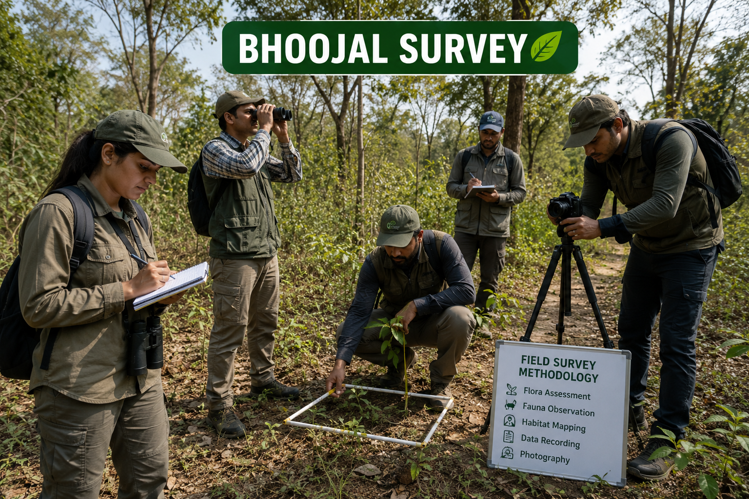
Ecological Survey Methodology: How Field Surveys Are Conducted
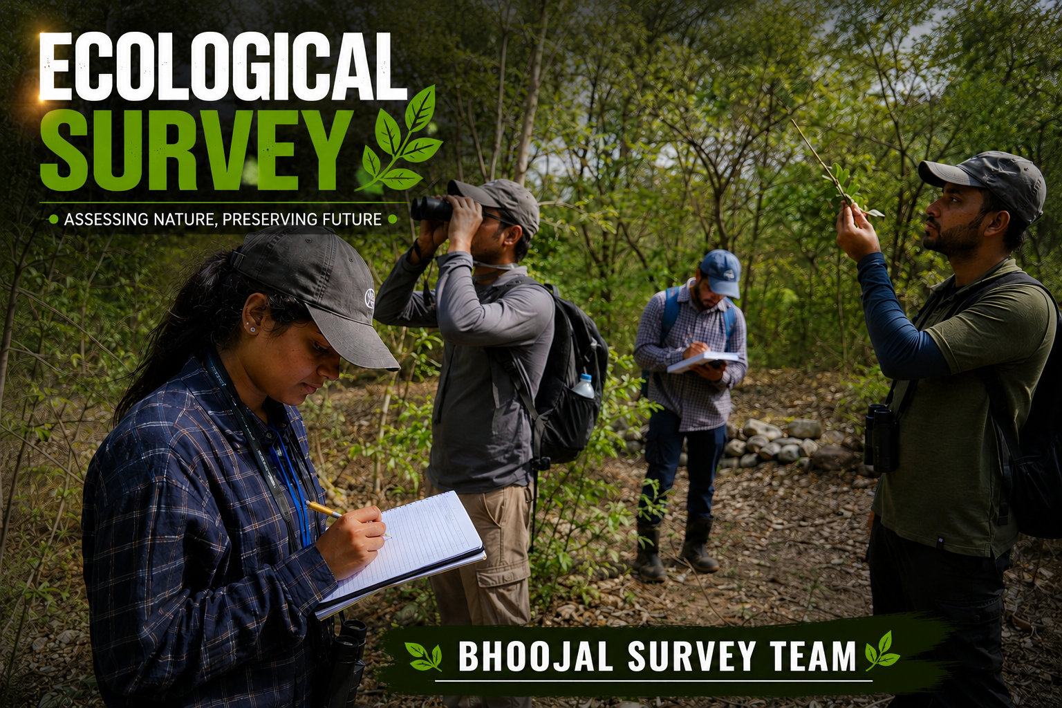
Professional field surveys follow rigorous, repeatable methodologies endorsed by the Chartered Institute of Ecology and Environmental Management (CIEEM). Our ecology consultancy team at Bhoojal Survey applies these frameworks on every assignment.
Phase 1 Habitat Survey and Preliminary Ecological Appraisal
The Phase 1 Habitat Survey — also known as a Preliminary Ecological Appraisal (PEA) — is the starting point for almost every project. It involves a walkover survey of the site to map habitat types, identify broad ecological features, and flag potential constraints for further detailed surveys.
A PEA is not exhaustive. It is designed to identify any ecological issues early and determine whether phase 2 surveys for specific protected species are necessary. Based on survey data gathered during this stage, we develop a targeted survey calendar for specialist follow-up work.
Flora Assessment: Linear Transect and Quadrat Sampling
Within the Core Project Site, our ecologists mark systematic quadrats (typically 10m × 10m) across representative vegetation communities. Linear transects are walked at fixed intervals to record tree species, canopy cover, understory density, and ground flora composition.
Using a densiometer for canopy analysis, we capture vegetation indices that feed into NDVI calculations from satellite imagery. This dual approach — ground-truthed field surveys combined with GIS and ArcGIS/QGIS remote sensing — ensures our Land Use Land Cover (LULC) mapping meets MoEFCC reporting standards.
RET (Rare, Endangered, Threatened) plant species are cross-referenced against the Red Data Book of Indian Plants and IUCN categories. In Central India's landscapes, this often includes species from Madhya Pradesh's dry deciduous forests and riparian corridors.
Fauna Survey: Direct Observation and Indirect Evidence
Wildlife surveys in the Core Area use a combination of direct observation (dawn and dusk walks), indirect evidence (pugmarks, scats, pellets, burrows), and specialist monitoring equipment.
Bird surveys employ the Point Count method, with each observer recording all avifauna within a fixed radius over a timed period — typically 10 minutes per point, across a minimum of three repeat visits. This approach captures resident, migratory, and nesting species alike.
Nocturnal species including bats are surveyed using full-spectrum bat detectors. Bat activity transects and static detector deployments run through appropriate times of the year — typically pre-emergence surveys from April through to August. A bat licence from the Wildlife Crime Control Bureau may be required before any roost disturbance.
Camera trapping targets mammals across the Core Area, capturing species such as leopard (Panthera pardus), sloth bear (Melursus ursinus), Indian pangolin (Manis crassicaudata), and various deer species active after dark. Pugmarks and scat analysis complement direct sightings.
Reptile surveys using artificial refugia (corrugated tin sheets and roofing felt) are conducted during warm, overcast conditions when reptiles are most active beneath cover.
Analysing the 10km Buffer Zone
The 10km Buffer Zone study is where many ecological assessments fall short. This zone is not a bureaucratic formality — it is the analytical lens through which we assess landscape-scale ecological impacts, including habitat fragmentation, disruption to migratory paths, and proximity to National Parks or Wildlife Sanctuaries.
Within the buffer, our team conducts a Proximity Analysis of all protected areas, Reserved Forests, and ESZ boundaries. We assess landscape connectivity — the degree to which wildlife can move between habitat patches — and identify any linear features (roads, canals, transmission lines) that may act as barriers.
Migratory bird routes are mapped using published ornithological data, seasonal sightings, and point count records collected during survey work at different times of the year. For large infrastructure projects, this information directly informs the Ecological Impact Assessment submitted to regulatory bodies.
Hydrology and Aquatic Ecology
Water bodies within and around the development site are surveyed for aquatic ecology, including plankton, benthic invertebrates, fish, and riparian vegetation. Groundwater dependency of surface ecosystems — particularly wetlands and grassland communities — is assessed in relation to the project's potential impacts on hydrology.
This is where Bhoojal Survey's broader technical expertise adds distinctive value. Our team integrates ecological findings with hydrogeological data gathered by conducting hydrogeological survey using SSRMPATS Instrument, GER DETECT, and PQWT at site for open well/borewell location. This cross-disciplinary approach — combining advanced groundwater and geophysical survey solutions with ecological field data — gives clients a truly integrated picture of site sensitivity and groundwater-ecology linkages.
Impact Prediction, Mitigation and Compensation
Once species surveys and habitat mapping are complete, our ecologists produce a structured Ecological Impact Assessment (EcIA) that predicts both immediate environmental impact and long-term effects on species and habitats.
The mitigation hierarchy guides the response:
- Avoidance — redesigning project layout to exclude sensitive habitat areas and no-go zones.
- Minimisation — reducing the footprint, working outside breeding seasons, implementing dust suppression.
- Mitigation and compensation — habitat creation, translocation of protected species under licence, greenbelt planting with locally native species (Neem, Peepal, Arjun, Mahua).
Where great crested newt or bat roosts are confirmed, a detailed Wildlife Management Plan is prepared. This document sets out species-specific handling protocols, supervision arrangements, and post-construction monitoring commitments. The plan is submitted alongside the planning application for review by Natural England equivalents — in India, the relevant State Wildlife Board or the National Board for Wildlife.
Biodiversity net gain (BNG) principles are increasingly adopted in Indian project assessment frameworks, requiring developers to leave the natural environment in a measurably better state than before development.

Seasonal Variations and Modern Survey Technology
Ecological data must be collected across multiple seasons. A single-season survey risks missing breeding populations, overwintering species, or plant communities that are only detectable at certain times of year. Our survey calendar is designed to capture spring breeding activity, monsoon-season amphibian and reptile behaviour, and winter bird assemblages within a single reporting cycle.
Modern ecological reporting also integrates drone-based UAV surveys for mapping inaccessible terrain, and Environmental DNA (eDNA) analysis to determine the presence of protected species — particularly great crested newts and fish — in water bodies without intrusive netting. Scientific site investigation and resistivity analysis complement these ecological methods when assessing ground conditions and subsurface features.
Why Choose Bhoojal Survey
Bhoojal Survey is a trusted ecology consultancy and geophysical investigation firm with pan-India operational capacity. Our technical team comprises experienced surveyors, field ecologists, GIS analysts, and hydrogeological engineers who deliver integrated Environmental Clearance reports to the highest professional standards.
What sets us apart:
- Experienced technical survey team with proven delivery on industrial, solar, substation, mining, and government infrastructure projects.
- Advanced survey instruments including SSRMPATS, GER DETECT, and PQWT for combined geophysical-ecological investigations.
- Professional GIS analysis using ArcGIS and QGIS for LULC mapping and ZoI delineation.
- Fast reporting — preliminary reports within 7 working days of field survey completion.
- Fully compliant with CIEEM guidelines and the institute of ecology and environmental management's professional standards.
- Customised ecological and engineering solutions for project managers across EPC, solar, telecom, and infrastructure sectors.
- Transparent methodology, peer-reviewed species records, and defensible survey data for planning authority submissions.

Conclusion
An ecological survey is not a bureaucratic obstacle — it is a professional tool that protects both the natural environment and your project. Conducted properly, it identifies ecological constraints early, defines measures to avoid harm to protected species, supports a successful planning application, and contributes to sustainable development outcomes that satisfy regulators, communities, and investors alike.
Bhoojal Survey combines deep ecological field expertise with advanced geophysical and hydrogeological capabilities, giving clients a single, authoritative source for all their site investigation needs across India.
Contact Bhoojal Survey today for a project-specific consultation, fast-track ecological report, or integrated site suitability assessment. Our team is ready to support your Environmental Clearance from Phase 1 Habitat Survey through to detailed surveys, species licence applications, and post-construction monitoring.
Frequently Asked Questions (FAQs)
1. What is the standard radius for a buffer zone in an Ecological Survey? The standard buffer zone for most Indian infrastructure projects is 10km from the Core Project Site boundary. This 10km radius captures the Zone of Influence (ZoI) and allows ecologists to assess landscape connectivity, proximity to protected areas, and potential migratory route disruption.
2. Why is it necessary to study both Flora and Fauna in the 10km buffer? The 10km buffer may contain habitats and species that depend on ecological conditions within the core area. Animals move across landscape boundaries for food, breeding, and shelter. Flora within the buffer provides corridors and refugia. Assessing both gives regulators a complete picture of potential impacts.
3. What are RET species, and why are they important in a survey? RET stands for Rare, Endangered, and Threatened. These are species formally categorised by the IUCN Red List or the Wildlife Protection Act schedules. The presence of a protected species on a development site can require design changes, species-specific licences, and mitigation and compensation measures before planning permission is granted.
4. How long is an Ecological Survey report valid for Environmental Clearance? Under current MoEFCC guidelines, baseline ecological data should generally be no older than three years at the time of EC submission. However, for rapidly changing sites or sensitive species, fresh surveys may be required. Always confirm validity with your State PCB or the appraising authority.
5. What is the difference between a Phase 1 Habitat Survey and a Detailed Ecological Appraisal? A Phase 1 Habitat Survey (or Preliminary Ecological Appraisal) is a broad walkover to map habitat types and flag potential constraints. A Detailed Ecological Appraisal involves targeted, species-specific field surveys — such as bat surveys, reptile surveys, or bird surveys — conducted after the PEA has identified a need for further investigation.
6. Do we need an ecological survey for small-scale industrial projects? Yes, in many cases. Even small projects require an ecological assessment if they are located near protected habitats and species, Reserved Forests, or water bodies. A PEA is a cost-effective first step that identifies whether additional detailed surveys are necessary, helping you avoid costly delays during the planning application process.
7. How is GIS technology used in 10km radius surveys? GIS tools like ArcGIS and QGIS are used to delineate study area boundaries, produce LULC maps from satellite imagery, calculate proximity to protected areas, analyse habitat connectivity, and generate NDVI vegetation health indices. GIS-based spatial analysis is a core component of modern ecological reporting accepted by local planning authorities.
8. What is a "Wildlife Management Plan" in an ecological report? A Wildlife Management Plan is a formal document prepared when protected species are confirmed on a proposed development site. It outlines handling protocols, relocation procedures, supervision requirements, and post-development monitoring to ensure the presence of protected species does not lead to illegal harm. It is typically submitted with the planning application and may be made a planning condition of any consent granted.